
'Exceptional' Storm Floris triggers major travel disruption as 90mph wind gusts to batter Scotland


Trains to be halted north of the Central Belt from noon
A highly unusual fierce summer storm will cause major travel disruption across Scotland on Monday, with winds expected to gust up to 90mph as people were urged to avoid travel.
With Storm Floris due to sweep in from the Atlantic, all rail lines north of the Central Belt will be closed from noon, with sailings to be halted on multiple west coast ferry routes.
Edinburgh International Festival and Fringe shows have been cancelled, the Royal Edinburgh Military Tattoo is threatened and adjacent Edinburgh Castle will shut to visitors.
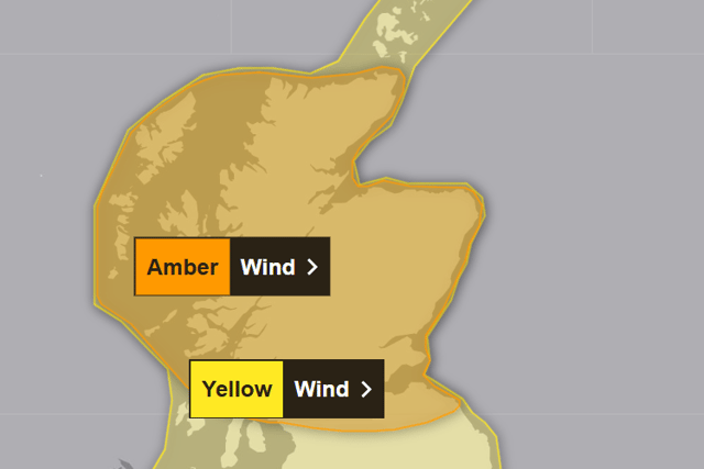
The precautions came after the Met Office escalated its yellow severe weather warning for Storm Floris to amber, with conditions expected to be “make akin to winter than summer”.
The Met Office raised the warning level for most of Scotland north from the Central Belt for what Transport Scotland described as “potentially exceptional weather” for the time of year.

The amber warning will be in force for 12 hours from 10am to 10pm on Monday.
A yellow warning covering the rest of Scotland and the northern half of the UK remains in place from 6am on Monday, but will now end at midnight rather 6am on Tuesday.
The amber warning is believed to the first for Scotland since Storm Éowyn in January and the country’s first such summer alert for strong winds for seven years.
Network Rail announced that all lines north of Dunblane would be shut from noon on Monday during what it described as an “unprecedented summer storm”. Roads and bridges are also likely to be affected, especially for lorries and other high-sided vehicles.
Rail routes to be closed are: Edinburgh to Fife, Perth and Dundee, Perth to Dundee, Aberdeen and Inverness, Dunblane to Perth, Inverness to Aberdeen, Wick, Thurso and Kyle of Lochalsh and Helensburgh Upper to Oban, Fort William and Mallaig.
A reduced timetable will operate with longer journey times on other lines because trains will be limited to 50mph from 9am, with trees at higher risk of being blown onto tracks because they are in full leaf. ScotRail ticket holders can travel on Sunday or Tuesday instead.
Network Rail said heavy rain would also increase the risk of landslips and flooding. The network operator said trains would not resume until later on Tuesday for routes to be checked.
TransPennine Express trains will be halted between Carlisle and both Glasgow and Edinburgh, and between Newcastle and Edinburgh. Ticket holders can travel on Tuesday instead.
Caledonian Sleeper has cancelled its services between Aberdeen, Fort William, Inverness and London on Monday night.
East coast train operators LNER and Lumo advised passengers not to travel north of Newcastle on Monday. LNER said ticket holders could travel on Sunday or until Wednesday instead, while Lumo passengers can use theirs on Tuesday or Wednesday.
London-Glasgow operator Avanti West Coast advised passengers not to travel north of Preston, and switch to Sunday or Tuesday instead.
CalMac has already cancelling ferry sailings on five of its west coast routes: Oban to Colonsay, and to Coll and Tiree; Barra to Eriskay; and Mallaig to Armadale and to the Small Isles.
Transport Secretary Fiona Hyslop said: “Given the unusual timing, and the fact some people will be on holiday, travelling or perhaps unaware, we are trying to raise even more awareness than usual of this potentially disruptive storm.”
The Edinburgh International Festival said its Ceilidh Sessions event had been cancelled because of the city council’s decision to close Princes Street Gardens due to the storm.
Events at the Fringe by the Sea festival in North Berwick have been cancelled on Monday. Meanwhile, the Edinburgh Festival Fringe Society said: “Should a show be cancelled, our customer services team will be in touch with customers who have purchased tickets.”
The Royal Edinburgh Military Tattoo performance on Monday night has also been cancelled.
A Tattoo spokesperson said: “Due to adverse weather warnings, we have made the difficult decision to cancel the performance on August 4 at 9.30pm.
“We understand this will be disappointing, but the safety of our audience, performers and staff is our top priority.
“All tickets for the 4th August performance will be automatically cancelled and refunded. Those wishing to rebook will find up-to-date availability at www.edintattoo.co.uk.”
Historic Environment Scotland said Edinburgh Castle would be closed on Monday along with other buildings including Craigmillar Castle, Stirling Castle, and Urquhart Castle beside Loch Ness.
Other buildings closed include Doune Castle, Bonawe Historic Iron Furnace and Dunstaffnage Castle in Argyll, Iona Abbey, Inchcolm Abbey in Fife, Lochleven Castle near Kinross, Stanley Mills in Perth, and Tantallon Castle in East Lothian.
‘Quite a vicious, nasty little feature’
Storm Floris is the sixth named storm of 2024-25 season, but the first to affect the UK since Storm Éowyn.
BBC Scotland weather presenter Judith Ralston said it would be “quite a vicious, nasty little feature”.
Transport Scotland said the expected conditions were “more akin to winter than summer”.
It said: “Much colder-than-normal air over Canada, clashing with heat building across the southern US, is supercharging the jet stream over the western Atlantic. A spell of heavy rain will also spread across the country, which could bring some flooding impacts, but is expected to move through relatively quickly.”
The Met Office said Storm Floris would bring a spell of “unusually strong west or north westerly winds” to much of Scotland during Monday. The forecaster said: “Gusts of 50 to 70mph are expected for many parts, and are likely to reach 80 to 90mph on some exposed coasts, hills and bridges.”
‘Relatively high rainfall accumulations’
Dan Suri, one of its chief meteorologists, said: “Western coastal areas will see the highest gusts late morning, with the strongest winds transferring to north eastern Scotland by late afternoon.
“Across the wider yellow warning area, many inland areas are likely to see gusts of 40-50mph, with 60mph likely at higher elevations and around some exposed coasts.”
The Met Office said “relatively high rainfall accumulations” would build-up over parts of north and west of Scotland, with 20-30mm falling quite widely and 40-60mm or more over some hills and mountains.
The forecaster said that in the yellow warning area, many inland areas were likely to see gusts of 40 to 50mph, with 60 to 70mph possible along exposed coasts and high ground.
Ross Moran, Network Rail Scotland route director, said: “With the severity of Storm Floris becoming clear, our priority is the safety of our passengers and colleagues. That is why we’ve taken the decision to close some parts of Scotland’s Railway early on Monday as the worst of the conditions hit the country.
‘This is a necessary step’
“Our engineers will also need to thoroughly inspect the network for any damage before we reopen the lines and restart train services on Tuesday morning.”
ScotRail service delivery director Mark Ilderton said: “We recognise the impact the withdrawal and alteration of train services will have on customers, but our first priority is always to ensure the safety of staff and passengers – and this is a necessary step.”
A CalMac spokesperson said: “Adverse weather conditions are likely to affect sailings, so to ensure the safety of customers and colleagues, several routes have either been cancelled or on alert for disruption or cancellation at short notice.”
Other ferry routes suspended on Monday include Corran across Loch Linnhe to the Ardgour peninsula, and between Cromarty and Nigg. NorthLink said there was a “high probability” of some cancellations between Caithness and Orkney.
‘Do not shelter close to buildings or trees’
The Met Office said driving in such conditions could be dangerous and urged motorists to slow down, be aware of high-sided vehicles and caravans on more exposed roads, and be cautious when overtaking.
It also advised drivers to give cyclists, motorcyclists, lorries, and buses more room than usual.
The Met Office said people should stay indoors as much as possible, and not walk or shelter close to buildings and trees. The forecaster also called on people to secure in advance for any loose items outside homes such as bins, garden furniture, trampolines, tents, sheds and fences.
Comments
Want to join the conversation? Please or to comment on this article.